Examine the formation of atmospheric tricellular circulation system. Describe how this system has been created considering the Earth a living planet.
The atmospheric tricellular circulation system is the primary mechanism by which the Earth redistributes solar heat from the equator to the poles. To examine this through the lens of a “living planet” (the Gaia hypothesis perspective), we must view these cells not as static mechanical loops, but as the planetary respiratory and circulatory system that maintains Earth’s thermal homeostasis.
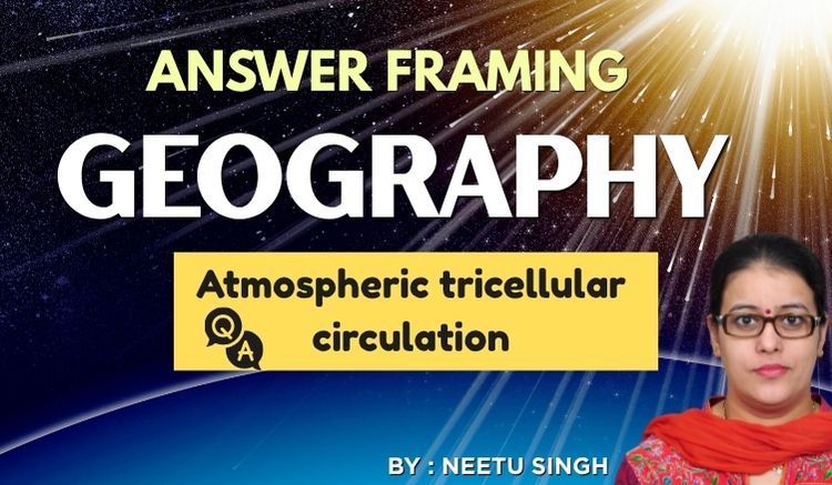
Formation Mechanism
- At the equator, the air near the surface is warm, winds are light, and the pressure gradient is weak. This region of monotonous weather is known as the doldrums. The warm air here rises, condensing into massive cumulonimbus clouds and thunderstorms, which release large amounts of latent heat as they form. The additional heat makes the air even more likely to rise, and provides the energy that drives the rising branch of the Hadley cell. This rising air reaches the stable tropopause, which blocks it from rising further, causing the air to diverge at upper levels and move poleward.
- Due to the Coriolis force, this upper level poleward flow is deflected to the right in the Northern Hemisphere and to the left in the Southern Hemisphere, providing westerlies aloft (near the tropopause) in both hemispheres in the Hadley cell.
- As air moves poleward from equatorial regions, it is constantly experiencing radiational cooling as it emits infrared radiation. Simultaneously, this air begins to converge and pile up as it approaches the mid-latitudes (around 30° latitude in both hemispheres). This convergence of air far above the surface increases the mass of air aloft, increasing the pressure at the surface. This increase in surface pressure results in a belt of high pressure centers called subtropical highsaround 30°N and 30°S. These latitudes are commonly known as the horse latitudes.
- As this converging air above the subtropical highs slowly descends, it warms adiabatically by compression. This sinking air, dries the atmosphere creating generally clear skies and little rain. Over the oceans, weak pressure gradients in the high centers produce weak winds. Some of these lighter surface winds begin to move back toward the equator, and are deflected by the Coriolis force. This causes northeasterly winds in the Northern Hemisphere and southeasterly winds in the Southern Hemisphere in tropical regions. These winds are known as the trade winds.
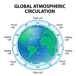
- Near the equator, the northeasterly and southeasterly trade winds converge at the surface at what is known as the intertropical convergence zone (ITCZ). Here, convergence further reinforces the rising branch of the Hadley cell.
- Back at 30° latitude, while some of the air sinking along the subtropical highs goes equatorward to complete the Hadley cell, some sinking air also moves poleward. This poleward moving surface air travels from from 30° to 60° and is again deflected by the Coriolis force. This results in the prevailing surface westerliesthat impact the mid-latitudes in both hemispheres. It is for this reason that weather moves west to east across the continental US. Often, this westerly flow is interrupted by high and low pressure systems that move with the mean surface flow. We’ll learn more about this in the next two chapters. As the surface air travels poleward from 30° to 60°, it collides with cold polar air moving equatorward. These air masses do not mix easily, and are separated by a boundary known as the polar front.
- At the polar front, surface air converges and rises at the subpolar low, and storms and convection develop here. Some of this rising air goes all the way up to the tropopause where it moves back to 30° latitude and sinks at the subtropical high along with the descending branch of the Hadley cell. This circulation cell from 30° to 60° is known as the Ferrel cell, which is a thermally indirectcirculation in which cool air rises and warm air sinks.
- Behind the polar front in the Northern hemisphere, cold surface polar air moves from the poles toward 60°. As the air moves equatorward, it is again deflected by the Coriolis force. In the Arctic regions, air typically flows from the northeast while in the Antarctic, air flows from the southeast. These are known as the polar easterlies. Along the polar front where cold polar air collides with warm air from the Ferrel cell, some of the rising air moves back toward the poles, which gets deflected as a westerly wind aloft. Eventually this air reaches the poles, sinks back to the surface, and flows back toward the polar front, which gives us thePolar cell.
 The Tri-Cellular Structure
The system consists of three distinct cells in each hemisphere: the Hadley, Ferrel, and Polar cells. Their formation is driven by the interaction of differential solar heating, the Coriolis effect, and the pressure gradient.
The Hadley Cell (The Tropical Engine) Role- Acts as the primary heat pump, transporting energy from the tropics to the subtropics.
The Ferrel Cell (The Atmospheric Gear) –It creates the prevailing westerlies, moving heat and moisture toward the poles.
The Polar Cell (The Thermal Sink) –Serves as the planetary cooling system, pulling cold air away from the poles and replacing it with warmer air from lower latitudes.
The “Living Planet” Perspective: Gaia and Homeostasis
The Gaia Hypothesis
Proposed by James Lovelock , the Gaia hypothesis posits that the Earth’s surface, atmosphere, and biosphere function as a single, unified, self-regulating organism.
Life doesn’t just adapt to the environment; life actively modifies the physical environment (atmosphere, ocean salinity, temperature) to keep it suitable for its own survival.
The Analogy: If Earth were a living body, the atmosphere is its breath, the oceans are its circulatory system, and the forests are its lungs.
Example: The regulation of atmospheric oxygen levels at a steady ~21%. If it were much higher, the Earth would spontaneously combust; if lower, complex life could not breathe. Gaia theory argues that biological life (plants/plankton) manages this balance through photosynthesis and respiration.
Homeostasis (Planetary Equilibrium)
Homeostasis is the biological process by which a living system maintains internal stability while adjusting to external changes. In Earth science, it is the state of dynamic equilibrium.
The Mechanism: Homeostasis relies on Feedback Loops:
Negative Feedback (Stabilizing): These loops act like a thermostat. As the temperature rises, the system triggers a reaction that cools it down.
Example: Higher temperatures lead to more evaporation – more clouds – higher albedo (reflectivity) – cooling of the surface.
Positive Feedback (Destabilizing): These loops accelerate a trend, potentially pushing the system toward a “tipping point.”
Example: Warming melts polar ice – the dark ocean is exposed -heat absorption increases – more ice melts.
Viewing Earth as a living planet—where biological, chemical, and physical processes function in concert to maintain conditions for life—we can interpret these cells as vital organs:
- Thermoregulation (Homeostasis): Just as a human body sweats to cool down or shivers to warm up, the tricellular system is the Earth’s mechanism for “planetary thermoregulation.” Without this movement, the equator would be uninhabitably hot and the poles perpetually frozen, rendering the planet’s biosphere largely inert.
- Metabolic Exchange: The system is essentially a “respiratory system.” It facilitates the exchange of heat, moisture (water vapor), and kinetic energy across latitudes. This circulation allows for the creation of diverse biomes—from the lush rainforests fueled by the rising air of the Hadley cell to the arid deserts located beneath the sinking limbs of the same cell.
- Dynamic Equilibrium: The system is self-correcting. If one region becomes too warm, the circulation intensity increases to redistribute that energy. This is a manifestation of the Le Chatelier principle applied to planetary science, where the system acts to counteract any local destabilizing force.
Conclusion
Tricellular system is the geographical manifestation of the Earth’s self-regulating capacity, proving that the atmosphere, hydrosphere, and lithosphere act in a symbiotic, life-sustaining, unified whole.
- Climate Change as a “Systemic Fever”: Anthropogenic global warming acts like a pathogen introducing heat into a stable system. The tricellular system attempts to compensate, which manifests as intensified storm tracks, shifting jet streams, and expanded desertification zones (e.g., the expansion of the Hadley cell is causing arid zones to move into previously temperate regions).
- Jet Streams as the “Circulatory Pathways”: The boundaries between these cells (the subtropical and polar jet streams) are the “highways” of the system. Their recent “meandering” or “blocking patterns” are symptoms of the planetary system struggling to maintain stability under the stress of rapid warming.

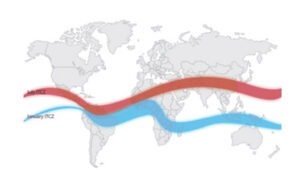

 The Tethys Ocean Squeeze: Before the collision, the Tethys Ocean separated the two landmasses. As the Indian plate drifted north, the oceanic crust subducted beneath the Eurasian plate. Once the ocean closed, the two buoyant continental masses collided.