Tag Archives: Geography Optional

India’s New Proposed Urban Criteria: Everything You Need to Know

The New Rules of Urbanization: India’s Proposed City Classification Criteria

India’s traditional framework for classifying urban areas is governed entirely by the Census of India. This system, which has remained largely unchanged since 1961, divides urban areas into two distinct classifications: Statutory Towns and Census Towns.

For a settlement to be officially declared “urban” in India, it must fall into one of these two categories.

Statutory Towns

Statutory towns are urban areas defined strictly by administrative and legal status. Regardless of their actual demographic characteristics, these places are notified by a state law or statute.

  • Definition: Any place that possesses an urban local government body.
  • Governing Bodies: This includes Municipal Corporations, Municipal Councils, Cantonment Boards, or Notified Town Area Committees.
  • Key Characteristic: They have a formal, legally recognized municipal administration to manage civic amenities.

Census Towns

Census towns are settlements that are administratively governed as villages (rural panchayats) but display distinct urban demographic characteristics. To be classified as a Census Town, a settlement must satisfy all three of the following criteria simultaneously:

Criterion Metric / Threshold
1. Minimum Population A population of at least 5,000 inhabitants.
2. Workforce Composition At least 75% of the male main working population must be engaged in non-agricultural pursuits.
3. Population Density A density of population of at least 400 persons per square kilometer (or roughly 1,000 persons per square mile).

Note on Gender Bias: The traditional criteria specifically measure only the male main working population to determine the shift away from agriculture. This historical metric has faced criticism for ignoring female labor patterns in transitioning economies.

Urban Agglomerations (UAs) and Outgrowths (OGs)

To capture continuous urban expansion that spills across administrative boundaries, the Census uses the concept of an Urban Agglomeration (UA). A UA is a continuous urban spread constituting a town and its adjoining outgrowths.

  • Outgrowths (OGs): These are viable units like a railway colony, university campus, or military camp that sprout up just outside the statutory limits of a city or town but are physically contiguous with it.
  • UA Requirement: To be classified as an Urban Agglomeration, the core town (or at least one of the constituent towns) must be a Statutory Town, and the total population of the entire agglomeration must not be less than 20,000 (as per the latest available census data).

Grading Cities: Census Visual Classification (Tiers)

Once classified as urban, the Census traditionally grades these towns into six distinct classes based purely on population size:

  • Class I: 100,000 and above inhabitants (often referred to as Cities)
  • Class II: 50,000 to 99,999 inhabitants
  • Class III: 20,000 to 49,999 inhabitants
  • Class IV: 10,000 to 19,999 inhabitants
  • Class V: 5,000 to 9,999 inhabitants
  • Class VI: Less than 5,000 inhabitants (special administrative or tourist exceptions)


Recognizing that official data undercounts millions of people living in urban-like conditions, the Ministry of Housing and Urban Affairs (MoHUA), NITI Aayog, and the National Institute of Urban Affairs (NIUA) have proposed new frameworks to redefine “urban” India.

The latest proposed changes, frameworks, and structural transitions aim to map the country’s rapidly evolving urban landscape.

The Core Proposal: “Functional Urban Settlements”

To bridge the massive gap between geographical urbanization and rigid governance structures, the NIUA has recommended a new national settlement classification framework called Functional Urban Settlements.

  • The Mismatch: Under the existing framework, India recognizes only Statutory Towns (notified municipal corporations/committees) and Census Towns (villages meeting a population of 5,000, density of 400/sq km, and 75% male non-agricultural workforce).
  • The New Category: “Functional Urban Settlements” will capture peri-urban areas and rapidly transitioning villages that function like cities but are legally governed as rural panchayats.
  • Satellite-Driven Identification: Instead of relying strictly on administrative or population thresholds, the new framework proposes using Night-Time Light (NTL) data and satellite imagery to measure the intensity of built-up areas and illumination, creating a truer map of urban spread.

The Reality Check: While official census indicators peg India’s urbanization at roughly 31% to 36%, data mapping based on the UN’s Degree of Urbanisation framework suggests that nearly 84% of India’s population lived in functional urban settlements.

Uniform Reclassification of City Tiers

Historically, “Tiers” in India have been fractured—the Reserve Bank of India (RBI) uses one population scale for banking, while the Central Pay Commission uses an X, Y, and Z tier system for house rent allowances.

MoHUA is finalising a standardized, uniform classification of Tier-2, 3, 4, and 5 cities to drive differentiated policy, planning, and targeted investments:

  • Tier-1 Restructuring: Tier-1 metropolitan cities are being split into three distinct sub-categories based on population scale to better allocate massive infrastructure funds.
  • Tier-2 to Tier-5 Standardization: Smaller urban centers and fast-growing rural hubs are being assigned standardized parameters (combining population, local GDP, and corporate presence) to ensure they receive appropriate civic funding rather than being treated as simple rural zones.

Shift from “Towns” to “City Economic Regions” (CERs)

Economic and spatial planning is moving beyond strict municipal boundaries. The government is advancing the concept of City Economic Regions (CERs).

  • CERs map integrated supply chains, local labor markets, and surrounding satellite towns together as a single strategic economic hub.
  • Financial assistance and budget allocations are increasingly being tied to these functional regions rather than strict city-limit boundaries.

Mandate for “City Spatial and Economic Plans”

The Economic Survey emphasizes that future urban policy must focus on system performance. For all million-plus cities, a statutory 20-year City Spatial and Economic Plan (updated every 5 years) has been proposed. These plans introduce three non-negotiable criteria for urban development:

  1. A comprehensive mass transport network plan.
  2. A housing supply plan with fixed annual unit targets to prevent slum proliferation.
  3. A land-value capture framework explicitly linked to high-growth infrastructure corridors.

 

air masses and local winds

Explain the relationship between air masses and local winds.

In climatology, the relationship between air masses and local winds is a classic study of scale, interaction, and modification.

While air masses represent macro-scale (synoptic) atmospheric phenomena covering thousands of kilometers, local winds are micro-scale to meso-scale systems confined to specific topographies. Their relationship is highly dynamic: air masses define the broad atmospheric canvas, while local winds either arise from their boundaries, modify their internal structures, or act as conduits that transport them.

Local Winds Generated by Air Mass Boundaries (Frontal Dynamics)

When two contrasting air masses meet, the boundary (front) generates sharp pressure and temperature gradients, which trigger localized, high-velocity winds.

  • Squall Lines and Gust Fronts: Ahead of an advancing Continental Polar (cP) air mass, the aggressive lifting of a warm Maritime Tropical (mT) air mass creates severe convective thunderstorms. The downdrafts from these storms hit the ground and spread out as a gust front—a violent, localized wind shift accompanied by a sharp drop in temperature.
  • Blizzards: The interaction between a blocking Arctic air mass and a passing mid-latitude cyclone creates a tight pressure gradient. This fuels localized, high-velocity winds that pick up loose snow, creating blizzard conditions.

Air Masses Restricting or Enhancing Local Thermal Winds

Local diurnal winds like land/sea breezes and mountain/valley breezes rely entirely on localized thermal gradients. Large-scale air masses can either suppress or amplify these winds.

  • Suppression by Stable Air Masses: If a region is dominated by a highly stable, subsiding air mass (such as an anticyclonic Continental Tropical (cT) mass), it creates a strong temperature inversion aloft. This upper-level stability dampens vertical air movement, weakening valley breezes or weakening the inland penetration of sea breezes.
  • Amplification by Cold Air Masses: When a cool Maritime Polar (mP) air mass hovers just offshore next to a sun-baked coastal landmass, the regional thermal contrast is maximized. This intensely amplifies the daily sea breeze, making it penetrate much further inland.

Local Winds as Agents of Air Mass Modification

Certain local winds are explicitly created when a large air mass encounters topographic barriers, transforming the air mass’s original characteristics through adiabatic processes.

  • Katabatic Winds (Gravity-Driven Cold Air): When a cold, dense Continental Arctic (cA) air mass pools over a high-altitude plateau (like Greenland, Antarctica, or the Alps), gravity pulls this heavy air down the slopes. This creates violent, localized cold winds like the Mistral (Rhône Valley) or the Bora (Adriatic Sea), which export the arctic air mass’s characteristics to coastal valleys.
  • Föhn / Chinook Winds (Adiabatic Warm Winds): When a moist air mass (such as mP) is forced over a mountain range, it drops its moisture on the windward side. As it descends the leeward side, it undergoes compressional heating at the dry adiabatic lapse rate .It emerges at the base as a hot, exceptionally dry local wind known as a Chinook (Rockies) or Föhn (Alps), completely modifying the local microclimate.

Local Winds as Transporters of Air Mass Characteristics

In many parts of the world, named local winds are simply the regional names given to the vanguard or edges of a migrating air mass.

  • The Harmattan: In West Africa, during winter, the dry Continental Tropical (cT) air mass over the Sahara pushes southward. The local wind that carries this dusty, ultra-dry air over the Gulf of Guinea is called the Harmattan.
  • The Loo: In the Indo-Gangetic plains during May and June, intense insolation creates an localized low-pressure trough. This draws hot, dry cT air from the Thar Desert, manifesting as the Loo—a highly localized, scorching afternoon wind.

Key Local Wind Regimes Dictated by the Siberian Continental Polar or Continental Arctic

It is characteristically bitterly cold, deeply dry, and highly stable .This causes the air to become incredibly dense and sink, forming a powerful anticyclone.

When this cold, dense air spills out of the Siberian reservoir, it is funneled by local topography into distinct regional wind regimes across East Asia.

The Winter Monsoon Winds (Northwest & Northeast Monsoon)

The primary outward rush of the Siberian High creates the East Asian Winter Monsoon. As the air moves, the Coriolis force and regional terrain split it into two distinct local wind flows:

  • The Northwest Monsoon (Northern East Asia): Sweeps across Northern China, Korea, and Japan. It is screamingly cold and dry, plunging temperatures across Beijing and Seoul well below freezing.
  • The Northeast Monsoon (Southern China & South China Sea): As the wind reaches lower latitudes, it is deflected by the Coriolis force to blow from the northeast, bringing dry, cool, clear winter conditions to Southern China and Vietnam.

The Karaburan (Black Blizzard) of the Tarim Basin

To the west and southwest, the outflow from the Siberian High encounters the massive deserts of Central Asia.

  • Mechanism: Cold air from the high-pressure system slips through gaps in the Tien Shan and Altai mountain ranges, rushing into the low-lying Tarim Basin (Taklamakan Desert).
  • Local Wind Dynamics: This creates the Karaburan, a violent, localized northeasterly wind. Because the incoming air is incredibly dense and fast-moving, it kicks up massive quantities of fine silt and sand, completely darkening the sky (hence “Black Blizzard”). It causes severe soil erosion and limits winter visibility to near zero.

The Buran / Purga of the Steppes

  • Mechanism: Across the open Russian steppes and Kazak plains, there are no mountain ranges to block the northern edge of the Siberian High’s circulation.
  • Local Wind Dynamics: When a low-pressure system moves along the periphery of the Siberian High, the pressure gradient spikes. This unleashes the Buran (or Purga when accompanied by snow)—a violent, freezing blizzard wind. It blows at gale forces, lifting existing snowcover into blinding sheets of ice-dust, creating life-threatening whiteout conditions across the plains.

The Hadashi / Oroshi Winds of Japan

When the Siberian High’s cold air mass travels eastward, it must cross the Sea of Japan before hitting the Japanese archipelago. This creates a brilliant two-step local wind and weather phenomenon:

  1. Thermodynamic Modification: The dry Siberian air mass moves over the warm Tsushima Ocean Current. It gets heated and humidified from below, transforming dynamically into an unstable Mp air mass
  2. Topographic Funneling (The Oroshi): As this modified air hits the central mountain spine of Japan, it is forced upward, dumping massive “sea-of-Japan effect” snow on the western slopes. Once the air clears the peaks and spills down the eastern leeward side toward Tokyo and the Pacific coast, it descends as a cold, dry, gusty local wind known as the Oroshi (or Hadashi, meaning “barefoot wind” due to its piercing coldness).

Discuss the mechanism and origin of Monsoon

Discuss the mechanism and origin of Monsoon winds and explain the role of El Nino on Monsoon circulation.

Introduction The Indian Monsoon is a seasonal reversal of winds driven by complex thermal and pressure gradients. Rather than a single local event, it is a global atmospheric phenomenon involving the interaction between land, ocean, and the upper-tropospheric circulation. Its origin is explained by two primary schools of thought: the Classical (Thermal) theory and the Modern (Dynamic) theory.

Mechanisms and Origin of Monsoon Winds

The Classical Theory (Edmond Halley)

This theory views the monsoon as a giant land-sea breeze.

  • Summer Monsoon: During summer, the sun is overhead the Tropic of Cancer. The vast landmass of Asia (specifically the Tibetan Plateau) heats up intensely, creating a low-pressure zone. Simultaneously, the Indian Ocean remains relatively cooler (high pressure). Air moves from the high-pressure ocean to the low-pressure land, bringing moisture-laden winds.
  • Winter Monsoon: The process reverses in winter as the sun moves to the Tropic of Capricorn. The land cools rapidly (high pressure), while the ocean retains heat longer (low pressure), causing winds to blow from land to sea.

The Modern Theory (Dynamic)

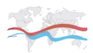
Modern meteorology attributes the monsoon to the seasonal migration of planetary pressure and wind belts, specifically the Inter-Tropical Convergence Zone (ITCZ).

Shift of the ITCZ: During the summer, the ITCZ shifts north of the equator to create  Monsoon Trough. This draws the southeast trade winds across the equator. As they cross, the Coriolis force deflects them to the right, transforming them into the Southwest Monsoon.

The Role of Jet Streams:

  • Tropical Easterly Jet (TEJ): In summer, a powerful easterly jet stream flows at high altitudes (near the tropopause) from East to West over the Indian peninsula. It is believed to assist in the “pumping” of air, intensifying the low-pressure system over the Indian subcontinent, thereby strengthening the monsoon.
  • Sub-Tropical Westerly Jet (STWJ): During winter, the STWJ blows south of the Himalayas. For the monsoon to set in (summer), this jet must retreat northwards (tibetan plateau heating is a catalyst for this shift).

The Role of El Niño on Monsoon Circulation

El Niño is a periodic warming of the sea surface temperatures (SST) in the central and eastern equatorial Pacific Ocean, which disrupts the normal Walker Circulation and acts as a major atmospheric “spoiler” for the Indian Monsoon.

Mechanism of Disruption

  1. Normal Conditions (Walker Circulation): Under normal conditions, strong trade winds push warm water toward the Western Pacific (near Indonesia/Australia). This creates a low-pressure area (warm, rising air) in the west and a high-pressure area (cool, sinking air) in the east. This helps maintain the monsoon moisture transport toward India.
  2. El Niño Conditions: The trade winds weaken or reverse. Warm water surges toward the South American coast. The convective “rising air” center shifts from the Western Pacific toward the Central/Eastern Pacific.
  3. Impact on India: This shift triggers a descending (subsiding) air limb over the Indian Ocean and the Indian subcontinent. High-pressure conditions over India inhibit the moist convection required for rainfall, leading to weak monsoon performance, drought, or delayed onset.

The ENSO-Monsoon Link

  • Teleconnections: The atmosphere acts as a bridge. The change in Pacific heating alters the global pressure distribution, which pushes the Tibetan High (the upper-air high-pressure cell that drives the monsoon) out of position or weakens it.
  • Inverse Correlation: Historically, strong El Niño years have frequently correlated with sub-par rainfall in India. However, the correlation is not always linear, as other factors like the Indian Ocean Dipole (IOD) can sometimes offset the negative impacts of El Niño.

  Supplementary Factors: IOD and MJO

While El Niño is a major driver, the monsoon is also modulated by:

  • Indian Ocean Dipole (IOD): A “positive” IOD (warmer western Indian Ocean relative to the east) can act as a buffer against El Niño, effectively “pulling” the monsoon toward India even when Pacific conditions are unfavorable.
  • Madden-Julian Oscillation (MJO): An eastward-moving pulse of cloud and rainfall near the equator that can bring “active” and “break” phases to the monsoon cycle on a 30-60 day timescale.

Conclusion The Indian Monsoon is a highly resilient but sensitive system. While the origin of the monsoon is fundamentally tied to the thermal heating of the Tibetan Plateau and the shifting of the ITCZ, its variability is governed by complex global teleconnections. El Niño serves as a primary disruptor of the atmospheric circulation, proving that the rainfall in rural India is deeply interconnected with the ocean-atmospheric dynamics of the distant Pacific.

Ecosystem Functions

Photosynthetic and Chemosynthetic organisms

Photosynthetic and chemosynthetic organisms are autotrophs, which are organisms capable of synthesizing their own food (more specifically, capable of using inorganic carbon as a carbon source).

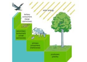
Photosynthetic autotrophs (photoautotrophs) use sunlight as an energy source, and chemosynthetic autotrophs (chemoautotrophs) use inorganic molecules as an energy source. Autotrophs are critical for ecosystems because they occupy the trophic level containing producers. Without these organisms, energy would not be available to other living organisms, and life would not be possible.

Photoautotrophs, such as plants, algae, and photosynthetic bacteria, are the energy source for a majority of the world’s ecosystems.

Photoautotrophs harness the Sun’s solar energy by converting it to chemical energy.

Chemoautotrophs are primarily bacteria and archaea that are found in rare ecosystems where sunlight is not available, such as those associated with dark caves or hydrothermal vents at the bottom of the ocean . Many chemoautotrophs in hydrothermal vents use hydrogen sulfide (H2S), which is released from the vents, as a source of chemical energy. This allows them to synthesize complex organic molecules, such as glucose, for their own energy and, in turn, supplies energy to the rest of the ecosystem.The feeding positions in a food chain or web are called trophic levels. The different trophic levels are defined in the Table below. Examples are also given in the table. All food chains and webs have at least two or three trophic levels. Generally, there are a maximum of four trophic levels.
Many consumers feed at more than one trophic level. Humans, for example, are primary consumers when they eat plants such as vegetables. They are secondary consumers when they eat cows. They are tertiary consumers when they eat salmon.

Trophic Levels

The feeding positions in a food chain or web are called trophic levels. The different trophic levels are defined in the Table below. Examples are also given in the table. All food chains and webs have at least two or three trophic levels. Generally, there are a maximum of four trophic levels. Many consumers feed at more than one trophic level. Humans, for example, are primary consumers when they eat plants such as vegetables. They are secondary consumers when they eat cows. They are tertiary consumers when they eat salmon.

https://youtu.be/Dsqwh5_0UfY

India’s Geography Gurus – Your Trusted Online Coaching

DIRECTION IAS  “Where Geography Excellence Meets Holistic Preparation” Neetu Singh Geography isn’t just an option; it’s our specialization. Our belief in our unique ability to convey Geography concepts is unwavering. Yet, we understand that General Studies and interview preparation are equally essential. Our all-encompassing package programs are designed to help students realize their dreams. We pride ourselves on fostering unique personality development and confidence-building techniques that transform students into confident individuals, fully prepared for success in the competitive world of exams and interviews.

  • Geography Optional
  • General Studies (GS – Geography)
  • GS Geography Mapping
  • As a leading and eminent name in the field of Civil Services’ preparation, DIRECTION ULTIMATE LEARNING EX.PVT LTD  has long been the ultimate destination for aspirants seeking top-quality training and practice. We have consistently upheld our commitment to providing aspirants with the best possible resources and guidance, making their journey towards success a smooth and rewarding experience.

How to clear UPSC with Geography Optional

General Outline

Give me six hours to chop down a tree and I will spend the first four sharpening the axe.

Well begun is half done!!

So the beginning of your optional preparation must be with extensive reading of prescribed syllabus. This must include not just the main headings but also the sub-topics.

While comprehending the syllabus, integrate NCERT – 11th and 12th standard along with certificate to Physical & Human Geography by G.C. Leong.

For preparing each topic, take basic references (mentioned later), Class notes and also the model answers. Selection of 2-3 sources caters static and dynamic part of syllabus sufficiently.

Coverage of every topic (with multiple revisions) must be followed on by analyses of question trend. This can be done by referring Question Paper Analysis. This helps in comprehension of question trends.

It is strictly not advisable to be selective in your preparation as natures of questions are more integrated and open-ended.

Making notes/pointers for every topic is always advisable as it helps in quick revision and answer formatting.

As approached in the classroom, best way to prepare the syllabus is the swing,e. integration of Paper-I and Paper-II topics.

With nature of questions asked becoming unpredictable, class room coaching and test series help cannot be ruled out.

Strategy and sources of preparation

The best preparation for tomorrow is doing your best today

The Physical Principles of Geography covers maximum of static and core segment of syllabus. This part can be divided into

  1. Geomorphology
  2. Climatology
  3.  Oceanography
  4.  Biogeography (with some parts of Environment Geography)

Geomorphology – is the study of relief. It requires aspirants to be aware of processes forming and modifying relief feature (Paper-I). Its application is in Paper-II – Relief features of India.

To prepare this topic, which is both technical and applicable,Suggested sources are

  • Physical Geography – Savinder Singh
  • Physical Geography – Strahler and Strahler
  • Geography of India – Khullar
  • Class notes (Model answers)

Climatology- is the study of atmosphere and weather mechanism. This topic is also more technical in nature and requires strong and clear comprehension in Paper-I. Its application in Paper-II is as Indian climate, rainfall pattern, cyclones, western disturbances, etc.

Involving same technical and applicable dimensions, the suggested sources are

  • Physical Geography – Savinder Singh
  • Physical Geography – Strahler and Strahler
  • Geography of India – Khullar
  • Class notes (Model answers)

Oceanography– the study of oceans and marginal water bodies, is less technical and least prominent part of Physical Geography. The natures of questions are comparatively easy to comprehend. Suggested sources are

  • Physical Geography – Savinder Singh
  • Physical Geography – Strahler and Strahler
  • Geography of India – Khullar
  • Class notes (Model answers)

Biogeography – including fundamental principles of ecology, is the most sought after topic of syllabus. Its contemporary aspect makes it far more overlapping in nature – Biomes, vegetation, soil, Gene pool centres as the topics involves strong foundation for applicable parts as sustainability.

Paper II Indian vegetation, biome, soil, wildlife relates to the same in regional perspective. Suggested sources are –

  • NCERT Biology XII Std.
  • Class notes (Model answers)

Environment Geography – It is applicable part of biogeography and ecology. It is about degradation, climate change, causes, consequences, mitigation and adaptation strategies – World and India.

Extremely dynamic and marks-fetching topics are sincerely advised to be prepared in minutest details for both papers. Suggested sources are –

  • UNEP Report
  • IPCC Report
  • Terra Green
  • Down to Earth
  • Annual Report of MoEFCC
  • Class notes (Model answers)

The Fundamentals of Human Geography – It is the most dynamic part of syllabus which has feedback links with physical principles of geography as well.Also it is the scoring part of the syllabus as individual approach to answer writing is given higher remuneration.

Perspective in Human Geography- It is the most sought after and difficult topic of syllabus.It is about genesis and development of Geography as a discipline. It provides aspirants the understanding of Geographers and their contributions.

The prescribed syllabus though is more approaches and methods oriented, rather than scholar’s contributions.  Chronology of development of ideas is a must, in its preparation.

In last few years, the questions from this topic has not just increased (2018 Main as example), it has also been made applicable.

While preparing this topic, it must be considered that it grooms aspirants’ capacity to the maximum in writing good answers as it helps in quoting examples of Geographic contributions.

It do include the topics as language, Religion, Cultural Regions, HDI as applicable aspects of thought.

Suggested sources are

  •   Fundamentals of Geographical Thought – Sudeepta Adhikari
  •   Geographical Thought – R.D. Dixit
  •    Class notes (Model answers)

Population Geography and Cultural Setting- Based on UNFPA and Census data table, population geography includes static nature for 10 years for both Papers I and II.

However, population as social capital, social well being and quality of life makes applicable topics in Paper I.

Similarly, health indicators, population problems and policies of Paper-II are applicable topics. Suggested sources are

  •   Class notes
  •   Model answers
  •   Fundamentals of Contemporary Human Geography – Mona Domash

Settlement Geography- In Paper-I, syllabus is more theories-oriented. Absolute clarity of terms and scholars is required.

However in Paper-II, Contemporary thus open ended dimension of town problems and planning makes it marks fetching.

Suggested sources are

  • Human Geography – Majid Hussain
  • Urbanisation & Urban systems in India – R. Ramachandran
  •  PIB for town planning and problems
  •  Class notes

Economic Geography- In Paper-I, the syllabus is less extensive though includes topics that are dynamic in nature as World Economic Development, Food & Nutrition Problem, Patterns of world trade

It is more extensive and applicable in Paper-II involved with significance of all Government policies and programmes.

Divided into Agriculture, Industrial Geography, Trade transport and communication. Syllabus has an absolute applicable dimension.

Suggested sources are

  •   PIB
  •    Class notes (Model answers)
  •   Economic Geography – Leone & Morgan
  •   FAO Report
  •  World Development Report

Regional and Political Geography- These topics in Paper-I again has static, theoretical dimensions in combination to dynamic aspects as planning for sustainable development and geopolitical significance of different geographic regions, i.e. application of geopolitical theories.

Paper-II involves overlap of entire syllabus with these topics as both physical and human aspects influences level of development, thus planning also a political significance.

Suggested sources are

  •   Yojna and Kurukshetra magazines
  •    Political Geography – S. Adhikari
  •    Rupa made simple Part-II
  •    Class notes

Models, theories and Laws in Human Geography- This topic of Paper-I holds its significance at par with perspectives in development of Human Geography.

It includes all the major theories and models of human geography. Application aspects of these require understanding of  present scenario of human geography sources.

Suggested sources are

  •     Class notes
  •    Political Geography – S. Adhikari
  •     Human Geography – Majid Hussain

ALL THINGS ARE READY, IF OUR MIND BE SO

Toppers Answer Copy 

Pratham Kaushik (Rank 5 CSE 2017)

https://www.directionias.com/wp-content/uploads/2023/05/t-copy.pdf