Recent theories on mountain building
Mountain building (orogenesis) has evolved significantly from early vertical-movement paradigms to highly integrated horizontal and deep-mantle models. While classical concepts like Kober’s Geosynclinal Theory and Jeffreys’ Thermal Contraction laid the early groundwork, contemporary geomorphology explains mountain building through the Plate Tectonic framework and several recent additions involving mantle dynamics and climate-tectonic coupling.
The Foundational Framework: Plate Tectonics Theory
In contemporary plate tectonics, mountain building is recognized as polygenetic. While convergent zones produce the grandest planetary folds (orogens), divergent boundaries construct the Earth’s primary volcanic relief via thermal expansion and crustal extension, and transverse boundaries act as localized tectonic engines, transforming lateral displacement into rapid, high-angle structural uplifts through transpression.
Convergent Plate Boundaries
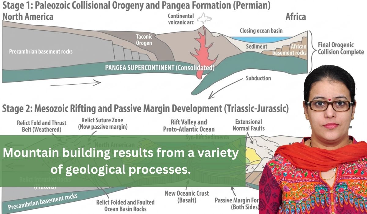
- Continent-Continent Collision: Explains the grandest fold mountains like the Himalayas and the Alps. Because continental crust is too buoyant to subduct deeply, the collision forces intense lateral compression, leading to crustal shortening and crustal doubling (where one plate underthrusts the other).
- Ocean-Continent Collision: Driven by the subduction of a denser oceanic plate beneath a lighter continental plate (e.g., the Andes and Rockies). This mechanism creates mountains via a combination of compressional folding, accretionary wedges (sediments scraped off the subducting slab), and widespread volcanic arc activity.
Divergent Plate Boundaries
At divergent boundaries, plates pull apart under tensional stress. While this crustal thinning creates low-lying rifts, it simultaneously generates massive mountain systems through two primary mechanisms: Thermal Buoyancy and Fault-Block Tectonics.
- Oceanic Divergence: Mid-Oceanic Ridges (MORs) The single longest mountain chain on Earth (over 65,000 km)—the Mid-Atlantic Ridge and the East Pacific Rise—is entirely engineered by divergent boundaries.
- Continental Divergence: Rift Shoulders and Fault-Block Mountains When divergence occurs on a continent, the crust undergoes brittle deformation, breaking along high-angle normal faults. The East African Rift System- The Ruwenzori Mountains and the volcanic peaks of Kilimanjaro and Mount Kenya are products of this continental rifting.
Transverse Plate Boundaries
- At transverse boundaries, plates slide past one another horizontally along strike-slip faults under shear stress. In a perfectly straight strike-slip fault, crust is neither created nor destroyed, and no vertical relief is generated. However, faults are rarely perfectly straight. Mountain building occurs due to a highly specialized tectonic process called Transpression.
Recent and Refined Concepts in Orogenesis
To address anomalies that basic plate tectonics cannot fully explain—such as rapid late-stage uplift or intraplate mountains—geologists have introduced several advanced modern theories:
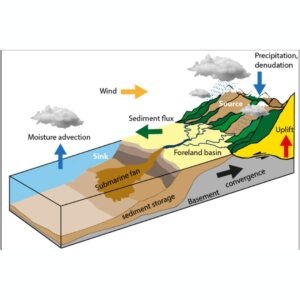
Modern geomorphologists (e.g., Peter Zeitler, Beaumont) have broken the old assumption that endogenic (internal) and exogenic (external) forces operate completely independently.
The Concept: Heavy atmospheric precipitation on the windward slopes of a rising mountain causes aggressive fluvial or glacial erosion. This rapid localized denudation unloads immense weight from the crust, triggering a rapid isostatic rebound (uplift).
- Application: This feedback loop acts like a “tectonic aneurysm,” drawing deeper, hot crustal rocks rapidly up to the surface. This perfectly explains the extreme, steep relief found at the structural syntaxes of the Himalayas (Nanga Parbat in the west and Namcha Barwa in the east).
Lithospheric Delamination (Convective Thinning)
During prolonged continental collisions, the underlying root of the mountain becomes incredibly thick and dense due to high-pressure metamorphism.
The Concept: Because this cold crustal root becomes denser than the underlying asthenosphere, it becomes unstable, breaks away, and peels/sinks into the deeper mantle.
- Application: Stripped of this heavy downward anchor, the remaining upper crust experiences a sudden, buoyant vertical snap upward. This explains the late-stage, rapid, and uniform flat uplift observed in the Tibetan Plateau and the Altiplano (Andes).
Terrane Accretion (Accretionary Orogeny)
Instead of viewing orogeny strictly as the collision of two massive, uniform continents, recent theories highlight the incremental stitching of the crust.
- The Concept: Oceans contain scattered island arcs, seamounts, and micro-continents. As an oceanic plate subducts, these fragments—called exotic or suspect terranes—are too buoyant to sink. Instead, they are sliced off the subducting plate and accreted (welded) onto the continental margin over millions of years.
- Application: The Western Cordillera of North America (including the Canadian Rockies) was built predominantly by the successive accretion of dozens of these distinct crustal fragments.
Dynamic Topography and Mantle Plumes
This theory accounts for broad vertical uplifts that happen far away from active plate boundaries.
- The Concept: Deep mantle convection cells and rising mantle plumes exert an upward hydrodynamic force directly onto the base of the lithosphere.
- Application: This creates high-altitude plateaus and thermal dome mountains without requiring horizontal crustal compression. The broader East African Rift topography are classic examples of plume-driven dynamic topography.
Flexural Isostasy Model
Moving past the simplistic, independent vertical column models of Airy and Pratt, modern views treat the lithosphere as a continuous, elastic sheet. When tectonic forces pile heavy rock sheets (thrust loads) onto a continent, the lithosphere bends under the weight. This flexure explains the simultaneous uplift of the mountain core and the structural sagging right next to it, which creates deep foreland basins (such as the Indo-Gangetic trough parallel to the rising Himalayas).
Analytical Conclusion
In a modern geomorphological context, mountain building is no longer viewed as a closed, purely mechanical endogenic event. It is written about in answer writing as a holistic Earth System process—a dynamic equilibrium where deep mantle convection currents, horizontal plate boundary interactions, elastic lithospheric flexure, and surface sub-aerial denudation continuously feed into one another to engineer the Earth’s relief.