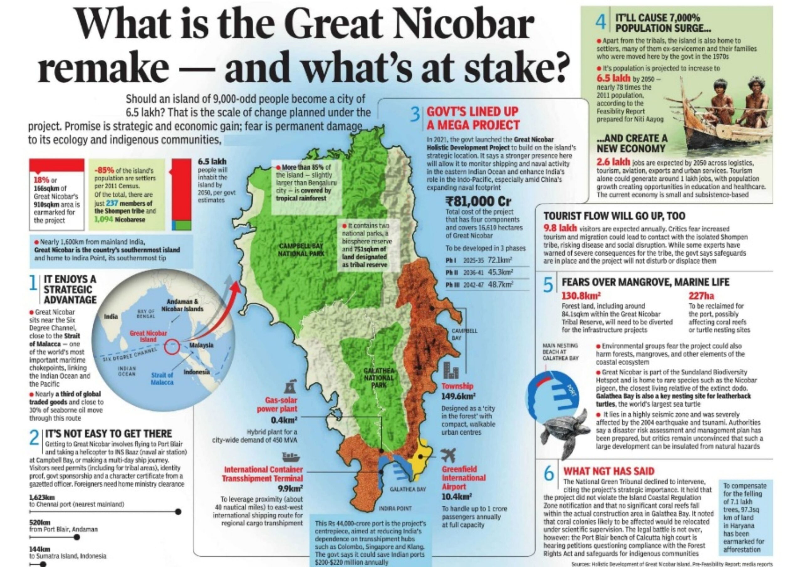
Great Nicobar is the southernmost and largest island of the Nicobar archipelago in the eastern Indian Ocean. The Absolute Edge: It houses Indira Point, the official southernmost tip of Indian territory. Geopolitical Hotspot: It is strategically perched right next to the Strait of Malacca, one of the busiest maritime trade choke points in the world.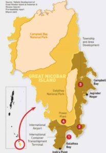
The mega-project spans roughly 166 square kilometers of land and is built around four foundational pillars:
International Container Transshipment Terminal (ICTT): Located at Galathea Bay, this deep-water port is designed to handle 14.2 million TEUs (Twenty-Foot Equivalent Units). It leverages a natural depth of over 20 meters to dock the world’s largest cargo ships. Greenfield International Airport: A dual-use civilian-military airport cleared for development to handle high-volume tourist traffic and accommodate advanced military surveillance aircraft. Gas and Solar Hybrid Power Plant: A 450 MVA power plant built to provide self-sustaining, low-interruption power to the new development. A New Smart Township: A sprawling urban development designed to support a projected influx of residents, service providers, tourism, and defense personnel.
Strategic & Economic Effects
The Indian government views the project as an initiative of paramount national importance. Its primary intended effects include: Geopolitical and Maritime Advantage: The island sits just 40 nautical miles from the Malacca Strait—one of the busiest shipping lanes in the world. The project significantly boosts India’s naval and defense surveillance presence in the Indo-Pacific, acting as a crucial maritime checkpoint. Economic Sovereignty: Currently, a massive chunk of India’s transshipment cargo is routed through foreign hubs like Colombo and Singapore. The ICTT will allow India to capture this revenue directly, reducing logistics costs and reliance on foreign ports. Global Tourism & Connectivity: Proximity to major Southeast Asian tourist hotspots (like Phuket and Langkawi) positions Great Nicobar to become a massive international transit and eco-tourism zone, driving major regional infrastructure growth.
Tribes: The Ancient Inhabitants
The island is home to two distinct indigenous communities whose lifestyles could not be more different, both heavily protected under strict tribal reserve laws: The Shompen: Classified as a Particularly Vulnerable Tribal Group (PVTG), the Shompen are a semi-nomadic, isolated group of hunter-gatherers living deep within the interior rainforests. They have historically avoided sustained contact with the outside world. The Nicobarese: Unlike the Shompen, the Nicobarese are traditionally settled horticulturists and marine fishermen. Originally living in coastal villages, a large portion of the population was forced to relocate inland to places like Campbell Bay after the devastating 2004 tsunami.
Impact on Indigenous Tribes
Encroachment on Tribal Reserves: The project overlaps with about 84 sq. km of the official Tribal Reserve, home to the isolated Shompen (a hunter-gatherer tribe) and the Nicobarese. Loss of Foraging Grounds: Although the government has firmly stated that no physical relocation of tribal habitations will happen and has expanded the overall reserve area elsewhere, activists argue that introducing hundreds of thousands of outsiders will permanently fracture the tribes’ isolation and alter their ancestral foraging ecosystems. Tribal Welfare -The Great Nicobar Project is fully aligned with the Shompen Policy of 2015 and the Jarawa Policy of 2004, which mandate that large-scale development proposals prioritize the welfare and integrity of Particularly Vulnerable Tribal Groups (PVTGs) and follow a structured consultation process.
Biodiversity: An Ecological Wonderland
Designated as a UNESCO Biosphere Reserve, Great Nicobar is a massive hotspot of endemism (species found nowhere else on Earth) due to its dense, pristine tropical wet evergreen forests.
The Star Fauna: Nicobar Megapode: A unique, endangered bird that doesn’t sit on its eggs; instead, it builds massive mounds of decomposing vegetation and soil to act as a natural incubator.
Leatherback Sea Turtles: Galathea Bay on the island’s south coast is one of the world’s most critical nesting sites for these giant marine turtles. Other Endemics: The crab-eating macaque, Nicobar tree shrew, and reticulated python. Flora: The island boasts over 650 species of plants, including rare tree ferns and unique orchids that thrive in its perpetual equatorial humidity.
Ecological and Wildlife Impact
Massive Deforestation: The project requires diverting over 130 sq. km of pristine tropical rainforest. It is officially estimated that up to 7.11 lakh (711,000) trees will be chopped down in a phased manner across development cycles. Coral Reef Destruction: Building the port at Galathea Bay threatens thousands of rare coral colonies. Plans by the Zoological Survey of India (ZSI) to translocate over 16,000 coral colonies have drawn heavy skepticism from marine biologists, who point out that large-scale coral translocation has a historically poor track record globally.
Threat to Endemic Species: Great Nicobar is a global biosphere reserve home to unique wildlife like the endangered Leatherback sea turtle (which uses Galathea Bay as a primary nesting ground), the Nicobar macaque, the salt-water crocodile, and recently discovered endemic species like the Lycodon irwini wolf snake.
Government Safeguards and Current Status
To address these heavy critiques, the Ministry of Environment, Forest and Climate Change (MoEFCC) has established independent oversight committees to monitor pollution and biodiversity. The government has also initiated a Compensatory Afforestation plan, planting trees thousands of kilometers away in states like Haryana and Madhya Pradesh to offset the local forest loss. Furthermore, environmental assessments have mandated strict building standards that adhere to the National Building Code for earthquake-resistant infrastructure. The project is moving forward in a phased manner, with Phase I scheduled to run through 2035.
Extreme Seismic Vulnerability
The island sits directly on a highly volatile tectonic boundary (Seismic Zone V). It is profoundly prone to massive earthquakes and tsunamis. During the catastrophic 2004 Indian Ocean earthquake, the island didn’t just get hit by giant waves—the actual topography warped, causing parts of the coast to permanently subside (sink) into the sea by several feet. Ongoing seismic swarms in the Andaman Sea constantly remind scientists that a volcanic or tectonic event is never far off.
Risk Assessment and Disaster Management
The island lies in a seismically sensitive and cyclone-prone region. To address this, a comprehensive risk assessment study has been conducted covering both natural disasters (tsunamis, earthquakes, cyclones) and anthropogenic risks (industrial hazards, accidents). A vulnerability and disaster management plan has been prepared, ensuring preparedness for emergencies. Moreover, the reliance on a hybrid power plant (gas and solar) ensures resilience against disruptions while reducing carbon emissions.


