“The Himalaya is still rising.

16
Jun
Introduction Unlike older, relict mountain systems like the Appalachians or the Urals, the Himalayas are young fold mountains born out of a colossal tectonic collision The Himalayas and the Tibetan Plateau to the north have risen very rapidly. In just 50 million years, peaks such as Mt. Everest have risen to heights of more than 9 km. The impinging of the two landmasses has yet to end. The Himalayas continue to rise more than 1 cm a year — a growth rate of 10 km in a million years! Scientists believe that the Eurasian Plate may now be stretching out rather than thrusting up, and such stretching would result in some subsidence due to gravity..
The Tectonic Setting: Continent-Continent Collision
The primary driving force behind the continuous rise of the Himalayas is explained by the theory of Plate Tectonics.
- The Mechanism: The Himalayas are located at a convergent plate boundary, specifically characterizing a continental-continental collision between the northward-moving Indian Plate and the relatively stationary Eurasian Plate.
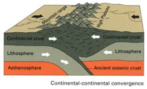 The Tethys Ocean Squeeze: Before the collision, the Tethys Ocean separated the two landmasses. As the Indian plate drifted north, the oceanic crust subducted beneath the Eurasian plate. Once the ocean closed, the two buoyant continental masses collided.
- Crustal Shortening and Thickening: Because continental crust is too buoyant to subduct deeply into the mantle, the intense compressive forces caused the crust to crumple, fold, and fault. This led to massive crustal shortening and a doubling of the crustal thickness (reaching up to 70–80 km beneath the Tibetan Plateau), forcing the landmass upward.
Geological Processes Driving the Uplift
The continuous vertical growth of the Himalayas is sustained through a combination of structural faulting and deep-seated crustal dynamics:
Major Thrust Fault Systems
The immense compression has sliced the northern edge of the Indian plate into massive rock slices bounded by south-verging thrust faults. As the Indian plate continues to push north, it slips underneath these faults, stepping up and lifting the mountain blocks above them. From north to south, these zones include:
- Indo-Tsangpo Suture Zone (ITSZ): The structural line marking the initial zone of collision.
- Trans Himalayan Fault (THF): The line between Trans Himalayas and Himadri
- Main Central Thrust (MCT): An older fault zone that propelled the crystalline rocks of the Greater Himalayas
- Main Boundary Thrust (MBT): The fault zone primarily responsible for the uplift of the Lesser (Middle) Himalayas.
- Main Frontal Thrust (MFT) / Himalayan Frontal Thrust (HFT): The youngest, southernmost fault system where the Shiwaliks (Outer Himalayas) meet the Indo-Gangetic plains. Active slip along the MFT is the principal contributor to the current rising of the outer mountain ranges.
- Isostatic Rebound
- The towering Himalayan peaks undergo intense denudation (erosion) driven by glaciers, heavy monsoon rainfall, and powerful river systems.
- As massive amounts of rock and sediment are stripped off the mountain tops and transported to the plains, the load on the underlying crust decreases.
- To compensate for this loss of mass, the Earth’s mantle pushes the deep, buoyant continental “root” of the mountains upward to maintain isostatic equilibrium (akin to a ship rising in water as cargo is unloaded). This interaction between surface erosion and deep crustal processes accelerates the uplift.
Evidences of Continuous Rise
The assertion that the Himalayas are still rising is supported by robust empirical, geomorphological, and geophysical evidence:
- Geodetic Data (GPS Measurements): High-precision satellite data show that the Indian plate is still moving northward into Asia at a rate of about 4 to 5 cm per year. This results in net Himalayan uplift rates ranging between 5 mm to 1 cm per year, depending on the specific structural zone.
- High Seismic Activity: The Himalayan arc is one of the most earthquake-prone regions globally (classified under Zones IV and V of India’s seismic zoning map). Frequent earthquakes represent the sudden release of locked tectonic stress along active thrust faults, directly resulting in instantaneous physical displacement and vertical uplift.
- Fluvial Geomorphology: Antecedent Drainage: Rivers like the Indus, Sutlej, and Brahmaputra existed before the mountains. As the land rose, these rivers carved deep, near-vertical gorges (such as the Indus Gorge) to maintain their original courses, proving that tectonic uplift outpaced the rivers’ lateral erosion.
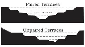
- River Terraces and Knickpoints: The presence of unpaired river terraces, steep waterfalls, and hanging valleys indicates structural rejuvenation, proving that the river beds are being uplifted repeatedly.
- Marine Fossils at High Altitudes: The presence of Ammonite fossils (locally known as Shaligrams) in the high-altitude Spiti Valley and Muktinath (over 3,000 meters above sea level) proves that sedimentary rocks forming these peaks were once part of the marine Tethys ocean floor.
Conclusion The rising Himalayas serve as a living laboratory for structural geology and geodynamics. This continuous tectonic uplift is not merely a geological phenomenon; it actively dictates the South Asian monsoon patterns, feeds the perennial river systems sustaining over a billion people, and shapes the geo-hazard profile (landslides and earthquakes) of the entire Indian subcontinent. Developing infrastructure in this fragile, still-evolving landscape requires a deep synchronization with these ongoing earth processes.
Go Back


